Defining BoundaryThe research began as an exploration into the landscapes around the River Nore. This lead to exploring the Abbeyleix Bog that helps regulate the water distribution along the banks of the river - a key role in the natural landscape. But, what interested me most about the bog was not just the unique vegetation but the scars left from the industrial history of the landscape. Dissecting through the center of the bog is the reminisce of the great southern railway line that connected Portlaoise to Kilkenny. It shaped how Abbeyleix town and countryside formed into today's model and allowed for a response into how to deal with industry hinterlands of rural towns.
During Semester II the initial research was to explore the repair and rejuvenation of industrial sites for connection back into the rural and urban landscapes. The principal design focus of semester two was the transformation of the Vitamin K factory and train shed into a community food hub which allowed the 14-acre site to become an oasis of allotments and gardens to grow and sell food making the citizens active users in their surrounding landscape. Therefore, fusing the town and landscape together with a network of boundaries allow for the distinguishment of an identity in the post-industrial peri-urban landscape. |
|
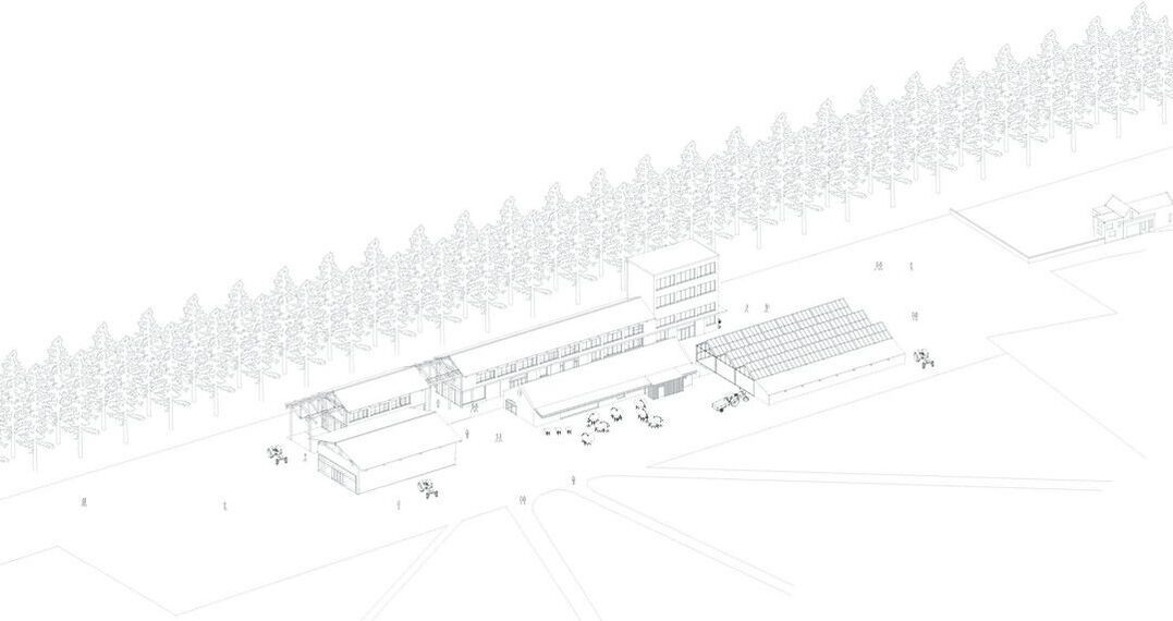
Initial Design | Interior condition
The architectural research project began with an exploration into the rejuvenation of the industrial peri-urban landscape in Abbeyleix and how this site in question can be the catalyst for regeneration and rejuvenation of industrial hinterlands.
The architectural design of the buildings focused on the use of existing structures with the introduction of new roofscapes over the concrete block shells with large double height spaces which functioned as spaces for markets, food festivals and spaces for the storage of food collected off the land. The buildings also opened new routes through the site creating links into the rural and urban conditions. The project at the end of semester two concluded that the new landscape created in the post-industrial site must communicate with the surrounding contexts with more rigid and regulated boundaries that allow definition in transition between the urban context, the enclosed gardens and then out to the rural condition.
The architectural design of the buildings focused on the use of existing structures with the introduction of new roofscapes over the concrete block shells with large double height spaces which functioned as spaces for markets, food festivals and spaces for the storage of food collected off the land. The buildings also opened new routes through the site creating links into the rural and urban conditions. The project at the end of semester two concluded that the new landscape created in the post-industrial site must communicate with the surrounding contexts with more rigid and regulated boundaries that allow definition in transition between the urban context, the enclosed gardens and then out to the rural condition.
Research design | Boundary condition
The research design comes from the opportunity’s boundaries provide to the social interaction among the community. The site in its current design from semester 2 creates a rich landscape within its defined limits but pass the threshold it loses its present in the peri urban landscape. The formation of walls enclosing the territory allow the edges of the site to become individual spaces that allow overlap between the outside working of the surrounding landscape and the inner working of the community gardens.
Citizens are the key piece to balance the tension between the new architectural intervention of the boundary wall against the surrounding buildings. The design is simply put that once the boundaries are formed the people learn to navigate the spaces and routes as they seem fit.
The boundary manifested itself in several ways through exploration of openings and closings, built functional forms or simply a dividing line of a hedgerow. Factors of economic and sustainability where also incorporated to the designs with the principal factors of materials, drainage, pedestrian accessibility, and biodiversity leading the characteristics of the proposals. In the following sections it reveals the breakdown of how each of the boundaries were studied and designed and how they function with the outer contexts of the surrounding landscapes.
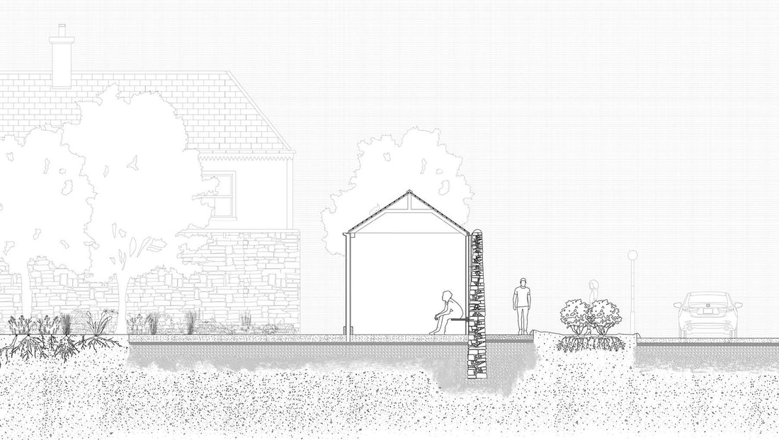
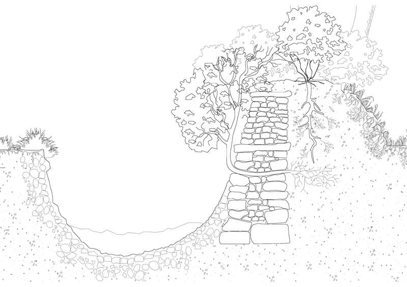
Condition 1 | Transitional boundary
The first boundary condition to be established was at the East edge of the site that was located next to the old Dublin to Cork Road. Due to the location, and the high amount of traffic that passes by the boundary on an average day it was determined a tall thick wall would be formed to protect the interior working of the gardens. But the formation of a wall would also allow the establishment of an open shed giving the boundary a functional space for the storage of the farm machinery. It would also provide a point of respite for users in which it could be a place to sit and relax. Inspired by traditional farm outbuildings and the hippodrome in Russborough House, the design of the structure is a mixture of a limestone traditional stone exterior, Cast iron interior columns and a timber roof structure.
It forms a transitional boundary from a heavy form on the exterior world into the sheltered conditions of the structure and opens out to the interior world of the gardens and orchards. The boundary occupies space that is neither on the external or interior world but simultaneously occupying both territories. Spaces for overlapping aren’t specialized places, but generators of activity.
The east boundary would only form the shed structures at key points of entrance into the site such as the main entrance at the North-East point to the centre of the east boundary which connects to the west of the site by a path. The structure would also form on the edge of the existing woodland on the east forming a transition from built form of the boundary wall into nature form of tree lined barrier. With each of the three paths on the East boundary defined by a formal entrance it creates a form of control with the large amount of the active users entering from these points and with the boundary having the most pedestrian interactive it Is key in forming the experience of the surround condition.
Condition 2 | Existing boundary
The second boundary condition is regarding the existing structures that forms the western edge of the site. The boundary in question is a traditional metre high stone-built wall that wraps around the existing woodland on the edge the site. To allow for integration into the existing landscape, the wall would be dissected at the point it sits parallel to the church lane allowing a direct path from the church pass the boundary wall into the woodland of the site. The entrance would be a simple opening in the stone structure reflecting off the similar style of the church entrance. Opening the boundary at this point allows direct connection of the school, church and houses to the hotel, shop and bog on the eastern edge giving a direct route through the new landscape of the community gardens out into the rugged rural landscape of the bog and forest.
The boundary would have minimal intervention with repairs to the mortar and replacements of the cap stones. The interior condition of the woodland would remove any of the trees that are at risk of damaging the foundations of the wall. The natural environment and the urban environment must co-exist harmoniously on this boundary especially in terms of tree roots and the damage they can have on the footpaths.
The boundary would have minimal intervention with repairs to the mortar and replacements of the cap stones. The interior condition of the woodland would remove any of the trees that are at risk of damaging the foundations of the wall. The natural environment and the urban environment must co-exist harmoniously on this boundary especially in terms of tree roots and the damage they can have on the footpaths.
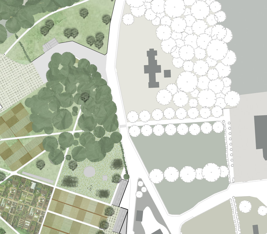
Condition 3 | Natural boundary
The Irish hedgerow is an instinct part of our rurality and is key in the establishment of boundary especially in the rural landscape. The introduction of a natural boundary on the southern edge of the site allows multiple functions to occur. It provides an eco-system for the forest behind the site to interact with giving wildlife opportunity to move from one context to another. It also gives protection against the river that is positioned south of the site especially in high rainfall seasons allowing the ditch and soil to absorb the excess water preventing flooding of the industrial buildings. The hedgerow is designed with a ditch formed against a bank of stone and dirt bank with a mixture of white thorn flowering hedges and mixtures of flowering trees planted on the bank. The introduction of hedges that produce fruits and flowers gives birds and bees ample food as well as providing shelter for them creating a habitat within the boundary. The natural boundary of the hedgerow not only forms a defined edge to the southern condition but also is the most sustainable and cheaper options of the four conditions.
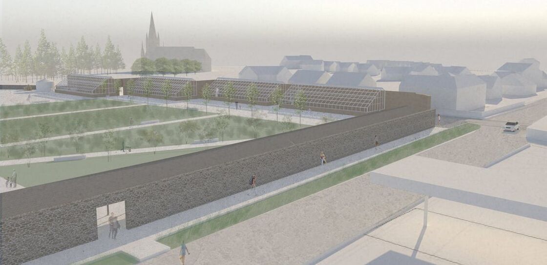
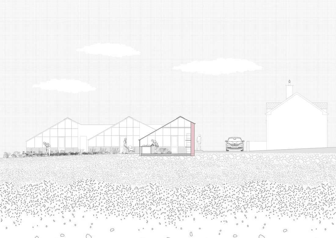
Condition 4 | Functional boundary
The final boundary condition is one of economic function, which is the introduction of greenhouses on the northern edge of the site. The greenhouses are designed with the orientation to the sun with the large amount of its glass surfaces facing the southern light. The northern edge of the site is positioned on a short residential street that connects the two main roads into Abbeyleix. Due to the road having limited car traffic and limited pedestrian movement it is ideal for this boundary to be a secluded entry point and suited for the residents who live in close proximity. This allows the community to enter the
gardens and greenhouses and perform daily task of maintenance and care without the need to enter the main public entrances. The form of the greenhouses is designed from traditional walled garden greenhouses that position the structure against a brick wall for insulation during the night. To allow for a consistent exterior design the outside of the wall is clad in the traditional stone with an insulated cavity of compacted clay for heat absorption and a brick interior for the heat to remain within the space. With the curve of the road on the north boundary the design of the wall and greenhouses would be staggered not only creating an architecturally engaging elevation but also allowing the greenhouses to absorb east light.
gardens and greenhouses and perform daily task of maintenance and care without the need to enter the main public entrances. The form of the greenhouses is designed from traditional walled garden greenhouses that position the structure against a brick wall for insulation during the night. To allow for a consistent exterior design the outside of the wall is clad in the traditional stone with an insulated cavity of compacted clay for heat absorption and a brick interior for the heat to remain within the space. With the curve of the road on the north boundary the design of the wall and greenhouses would be staggered not only creating an architecturally engaging elevation but also allowing the greenhouses to absorb east light.
Concluding remarks
This research project establishes the opportunities boundary can have on controlling and developing the outer periphery of Rural Irish Towns. The finding of the study shows the great importance in the investment and rejuvenation of the post-industrial landscapes. Defining the territory of theses spaces can be the first step in repairing the social fabric of the community. It allows planners to see beyond the zoning of potential development sites but more at the power of layering and the relationship that can be created that would free our urban and rural communities to create vibrant and innovative new ways of living together. By researching through drawing of boundary conditions and mapping out the possibilities they hold, landscapes can function in a resilient fashion with simple architectural intervention.
The relationship between people and their locality is no longer a one-way hierarchy relationship but instead a coexistence between spaces and borders and the interaction they preform to improve the health of rural suburban living.
The relationship between people and their locality is no longer a one-way hierarchy relationship but instead a coexistence between spaces and borders and the interaction they preform to improve the health of rural suburban living.
